Blizzard Warnings Issued as Potentially Biggest Snowstorm in Decades Heads for the Northeast
New York City and the surrounding Tri-State area are preparing for a significant nor’easter this weekend that forecasters say could bring heavy snowfall, strong winds, and dangerous travel conditions from late Sunday into Monday.
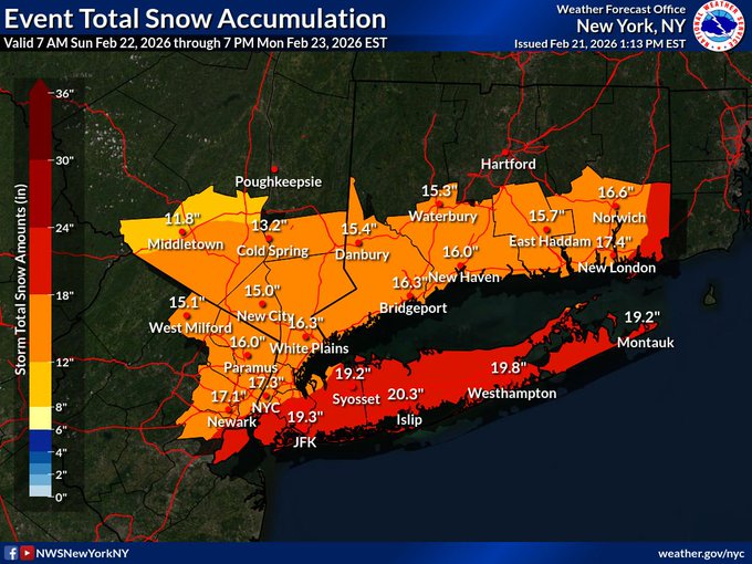
Meteorologists are forecasting steady snow beginning Sunday afternoon that will intensify overnight. The National Weather Service has issued blizzard warnings for New York City, Long Island, Connecticut, and parts of New Jersey — a designation that reflects the risk of sustained winds, blowing snow, and reduced visibility rather than just total accumulation. According to the latest forecasts, snow could fall at rates of 1–2 inches an hour during the height of the storm, with many areas in and around the city likely to see 12+ inches of snow, with some forecasts even predicting totals in the 20’s.

Strong winds are expected to accompany the snowfall, with gusts potentially exceeding 40–50 mph in some areas, creating whiteout conditions and drifting snow that could make roads impassable and slow plows. Forecasters also warn that coastal flooding may occur around shorelines. Airlines have already begun issuing advisories, and snow removal crews are staging equipment in anticipation of the worst of the storm. Officials are urging residents to avoid non-essential travel once snow becomes heavy, particularly Sunday night into Monday morning, when conditions are expected to be at their most severe.