Millions along the East Coast are set to get walloped by a massive blizzard that could drop as much as 24 inches of snow in some parts of the region stretching from New York City up to Boston and beyond, forecasters said.
More than 1,700 flights were canceled Saturday in anticipation of the treacherous conditions at major travel hubs like JFK, LaGuardia, Newark, and Boston Logan to ensure operational safety, according to FOX Weather.
That hasn’t happened for the city in nine years. And projected snow totals are rising for some of us.
The storm is predicted to begin Sunday and rage into Monday morning with wind gusts of more than 60 mph and with snow expected to fall between 1 and 3 inches per hour in some areas, causing experts to warn of potential power outages and coastal flooding.
New York Gov. Kathy Hochul declared a state of emergency for New York City, Long Island and Southern Westchester County beginning Sunday morning — ahead of the major nor’easter that will bring a predicted 18 to 24 inches of snow to the Big Apple alone.
“As our city prepares for levels of snow not seen since 2016, my administration is ready. We are activating every tool at our disposal to keep New Yorkers safe, informed and indoors,” said Mayor Zohran Mamdani. “We all have a role to play in keeping our communities and neighbors safe, and so while DSNY loads salt spreaders and DOT prepares our streets for snowfall, I am encouraging every New Yorker to stay inside and avoid travel.”
Extreme Impact Zones — when substantial disruptions to daily life are expected — have been expanded to include New York City and Boston, Fox Weather reported.
Travel will be treacherous and potentially life-threatening, the National Weather Service said. The blizzard warning takes effect at 1 p.m. Sunday and lasts through 6 p.m. Monday. Check the latest severe weather alerts for your neighborhood here.
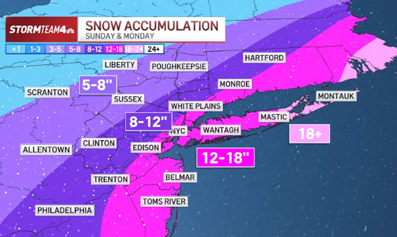
As of Saturday afternoon, forecasts showed at least a foot of snow is expected for the five boroughs, along with central Jersey and Nassau County on Long Island. More is certainly in the cards.
Some farther east on Long Island and down the Jersey Shore could see well more. Totals may be a little lower farther north and west, with parts of the Hudson Valley, North Jersey and Connecticut in the 5- to 8-inch range.
Snow will begin light with slightly above-freezing temperatures, so accumulations through Sunday afternoon will be relatively small. The heaviest snow will happen after sunset Sunday and continue into early Monday morning before it begins to taper off.
Travel Sunday night will be a mess, with heavy snow and gusty wind. The morning commute on Monday will be terrible, too. While the snow will be coming to an end, the winds will lead to blowing snow and reduced visibility, making roads awful to navigate.
The storm system will begin pulling away Monday afternoon, so conditions will begin to improve, with dry skies and sunshine taking over Tuesday.