New York (VINNEWS/Rabbi Yair Hoffman)
It is summer time, and many people are travelling to Yerushalayim to spend some time there. This would coincide with the first taanis of the summer. The Gemorah (Taanis 26a to 28b) lists five tragedies that occurred on Shiva Asar B’Tamuz:
- Foreshadowing what was to come, Moshe Rabbeinu found Klal Yisroel worshipping the golden Eigel when he came down from Har Sinai. He broke the first set of luchos on the 17th of Tammuz.
- During Bayis Rishon, there was a three year siege where Nevuchadnezzar managed to put a stop to the Korban Tamid that was offered daily by the Kohanim. It was not restored until the 2nd Beis HaMikdash was built. [Let’s think about that loss whenever we say the Korban Tamid.]
- On the 17th of Tammuz, the walls of Yerushalayim were broken into during the time of the 2nd Beis HaMikdash.
- During the time before the destruction of the 2nd Beis HaMikdash, a Greek general named Apostumos publically burned a Sefer Torah. It was a Sefer Torah written by Ezra HaSofer himself, and was the most authoritative one that we had.
- Apostumos placed a statue in the Beis HaMikdash. According to the Talmud Yerushalmi it was much earlier — and done by Menasseh Ben Chizkiyahu. We are not really sure whether Apostumos was a Greek General and he did it in the time before the Chashmonayim or if it was during the destruction of the second Beis HaMikdash or not.
It is the third of those five tragedies — the breaching of the walls of Yerushalayim during the time of the 2nd Beis HaMikdash — that draws our attention to the walls themselves. What were those walls?
Where did they stand, how were they built, and where exactly were they breached? Recent archaeology has brought much of this into sharp focus, and the picture that emerges allows us to stand, in our minds, on the very ground where the events we mourn took place.
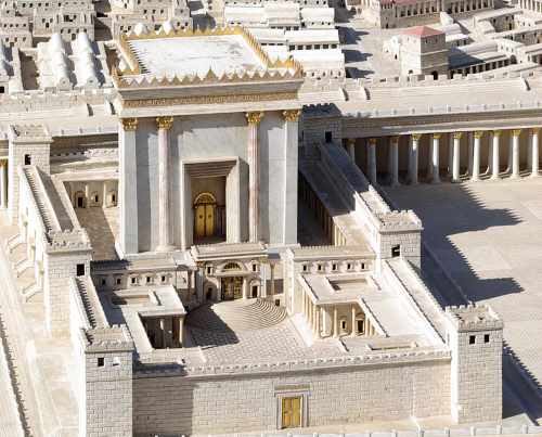
Yerushalayim at Its Largest
During the Bayis Sheini period, Yerushalayim was a busy, crowded city. According to Josephus, during the rule of Herod Agrippa the population reached about 120,000 people.
The Three Parts of the City
During Bayis Sheini Yerushalayim was made up of three main sections.
The Lower City sat on the smaller eastern hill, the same spot where the older Jebusite city had once stood. Its highest point, on the Har HaBayis, was 2,438 feet above sea level.
The Upper City was built on the western hill and was higher, reaching 2,549 feet above sea level. The city spread over this western hill during the later years of Klal Yisroel’s monarchy and during the period of the Chashmonayim.
Both the Lower City and the Upper City had a natural advantage: they had deep valleys that surrounded them. These valleys acted like natural walls and made Yerushalayim easier to defend, but they also limited how far it could grow. Together these two sections covered only about 161 acres.
The third section was called Beth-zeisa in Hebrew, meaning “olive orchard.” It was also known as the “new city.” Unlike the other two parts, it had no deep valleys to protect it. Because nothing blocked its growth, it spread north and became the largest part of the city, covering about 284 acres. Its highest point was in the northwest, at the Psephinos Tower, 2,625 feet above sea level. This was probably where the Russian Compound now stands.
At its largest, near the end of the Bayis Sheini period, the whole city covered about 445 acres. A wall surrounded it that was, on average, 33 feet tall and 13 to 16 feet thick. This made Yerushalayim the largest walled city in the country and one of the greatest in the entire Middle East. This wall marked not only defense but Kedusha. The Mishnah in Keilim (1:6–9) lists walled cities a rung of holiness above the rest of Eretz Yisrael, since metzoraim are sent outside of them. Yerushalayim, of course, is holier still.
The Three Northern Walls and the City’s Weak Point
Why the North Was Vulnerable
At the end of the Bayis Sheini period, three walls protected the northern side of the city. All three started at the same place: the Hippicus Tower, which is the Citadel near today’s Jaffa Gate.
Why did all three begin there? Because the land north of the line running from the Hippicus Tower to the Har HaBayis had no deep valleys to defend it. The Ben-Hinnom, Tyropoeon, and Kidron Valleys only became deep south of that line, so they could protect only the southern parts of the city. The north was the weakest spot — and that is where enemies chose to attack. The Gemara in Shvuos (16a) notes that the part of Yerushalayim added by those who returned from Bavel was not given the full kedushah of the city, since it was sanctified without a king and without the Urim VeTummim. Because that consecration lacked the full procedure, the Gemara observes, those less scrupulous about tumah and maaser would eat kodshim kalim there but not maaser sheni — a halachic sign that this newer, northern area stood apart from the older, fortified parts.
Building the Third Wall
The third wall was started during the reign of Agrippa, between 41 and 44 CE. It was not finished at that time, because Claudius, the Roman Emperor, suspected that Klal Yisroel was planning a rebellion and wanted the work stopped. Later, the Zealots finished the wall during the Great Revolt, in 66 CE.
The wall began at the Hippicus Tower and ran northeast, following roughly the same line as today’s wall, all the way to the Psephinos Tower. From there it followed the high ground that separated two drainage basins: the Ben-Hinnom stream basin to the southwest and the Tyropoeon Valley basin to the southeast. The wall then dropped steeply eastward along the line of today’s HaNevi’im Street, turned east toward the Kidron Valley, and ran just south of the Tomb of the Kings.
What the Diggers Found
Archaeologists have uncovered parts of this wall at several spots. In 1912, near the northwestern corner of the present city wall (close to the New Gate), L.H. Vincent discovered a fort called Kalat Jalud, or “Fort of Goliath.” This fort later played an important role in the fighting between Crusaders and Muslims in Yerushalayim, and stones from the third wall were found at its base. (Scholars today believe the standing tower itself was actually built much later, in the medieval period, even though older third-wall stones turn up around it. The Crusaders knew it as Tancred’s Tower.)
A section of the wall about 656 feet long and 15 feet thick was found in the foundations of the Italian Hospital, which is easy to spot because of its square tower. The Italian Hospital in Jerusalem is a historic Neo-Gothic building completed in 1919 by the Italian Barluzzi brothers and currently houses the Israeli Ministry of Education.
Researchers E.L. Sukenik and A.L. Mayer excavated these remains in 1924–25 and again in 1940. More of the wall can be seen on Nablus Street, about 1,476 feet north of the Damascus Gate, where one part is fenced off and another to the east is open to view. Other archaeologists later uncovered an additional 984 feet of the wall.
The bottom layers of the wall were made from a mix of small stones and mortar combined with fieldstones. On top of those sat large, finely cut stones called ashlars, shaped in the careful “Herodian” style; on average they measured about 3.94 by 3.28 feet. A few towers stood along the wall, sticking out about 26 feet and measuring 39 feet wide.
A Major Discovery: Proof of the Roman Attack (2016)
For most of the twentieth century, scholars argued about the exact path of the third wall and how far the city reached when the Romans attacked. In the winter of 2015–16, that debate took a major turn. During a dig in the Russian Compound — carried out before a new college campus was built — archaeologists Dr. Rina Avner and Kfir Arbib of the Israel Antiquities Authority uncovered the base of a large tower from the wall. It measured about 43 by 22 feet.
Right next to the tower’s western side, they found about 79 ballista stones and sling stones — the heavy projectiles the Romans had fired from catapults at the Jewish guards defending the wall. There was also a clear burn layer in the ground. Together, these finds are the physical traces of the Roman bombardment led by Titus in 70 CE.
The Romans fired these stones to drive the defenders off the wall so their soldiers could move in with battering rams and break through. This discovery matched the eyewitness account written by the historian Josephus, and it gave strong evidence for where the third wall really ran in the western part of the city.
Later work supported this picture. A 2023 mapping study, which used computer tools to combine all the older excavation records into one map, traced a continuous northern wall line and confirmed that the third wall brought Yerushalayim to its largest-ever size of about 445 acres — the figure described above.
A Major Discovery: Re-Dating the Bayis Rishon Wall (2024)
In 2024, a large scientific study by the Israel Antiquities Authority, Tel Aviv University, and the Weizmann Institute of Science changed how some of the earliest walls are dated. Using an improved form of radiocarbon (carbon-14) dating, the team studied about 100 carefully collected samples of ancient organic material from the City of David.
It was once thought that the Bayis Rishon–period city wall in the eastern part of the City of David was built by Chizkiyahu HaMelech, to defend Yerushalayim during the Assyrian siege. The new study suggests that this eastern wall was built earlier, during the reign of Uziyahu HaMelech, soon after a major earthquake struck the city.
The same research indicates that the city had spread westward already in the 9th century BCE — about a hundred years earlier than many had thought — and that Yerushalayim was more settled in very early times than once believed.
When the Walls Were Greatest — and When They Shrank
Yerushalayim’s walls were at their grandest during the time of Herod the Great and his successors. They were also at their longest then, enclosing about 445 acres. From Hadrian’s time until the Turkish period, the walls grew shorter and shorter, until the city reached its present size of about 232 acres.
After the Churban Bayis Sheini, the walls shrank inward toward the center — except during the Christian/Byzantine period, when they stretched out again. Titus completely destroyed the walls, and Hadrian rebuilt them, this time roughly following the line of the second wall. Chazal fixed that destruction on the calendar: the Gemara (Taanis 29a) teaches that the Beis HaMikdash caught fire toward the end of the ninth of Av and burned into the tenth — the same conflagration the archaeologists read in the burn layer by the third wall. In the north the new wall stuck out a little; in the south it ran very close to the Har HaBayis wall. The Roman city did not include the Beth-zeisa (new city) area or the southern slopes of the Lower and Upper Cities.
Meanwhile, the eastern and western walls from the Bayis Sheini period were mostly left standing after the Churban, because the deep Kidron and Ben-Hinnom Valleys protected them.
The Roman City Plan
The Roman city built by Hadrian and his successors had the typical Roman layout: two main streets crossing each other at right angles. These streets are clearly shown in the famous sixth-century Medeba map. They began at the city’s main gates, running from the Damascus Gate to the Zion Gate, and from the Jaffa Gate to the Har HaBayis and the Lions’ Gate. This design split the city into roughly four quarters — a layout that, with only small changes, still exists today.
A Major Discovery: Dating Wilson’s Arch (2020)
Scholars also argued for years about another famous structure connected to the Bayis Sheini period: Wilson’s Arch, the bridge that once carried mispallelim toward the Har HaBayis. Some thought it was built by Herod the Great around the time of the Bayis Sheini, while others believed it was much later, from the early Islamic period.
Between 2015 and 2019, an Israel Antiquities Authority excavation studied the arch in detail, and radiocarbon results published in 2020 settled the question. The first bridge to Har HaBayis was completed at roughly 20 BCE to 20 CE, placing it firmly in the Bayis Sheini period, and it was later made wider in the mid-first century CE. While digging, the team also made a surprising find: a small Roman theater-like structure hidden beneath the arch for about 1,700 years, which appears to have been left unfinished.
We began with the five tragedies of Shiva Asar B’Tamuz, and among them stood the breaching of the walls of Yerushalayim during the time of the 2nd Beis HaMikdash. The ballista stones lying beside the tower in the Russian Compound, the burn layer in the soil, and the Herodian ashlars uncovered along the third wall are the physical remains of the very breach that Chazal recorded.
May our recalling of these events, together with tefillah and maasim tovim, hasten the day when the walls of Yerushalayim are rebuilt and the Korban Tamid is once again offered, bimheirah b’yameinu.
The author can be reached at [email protected]